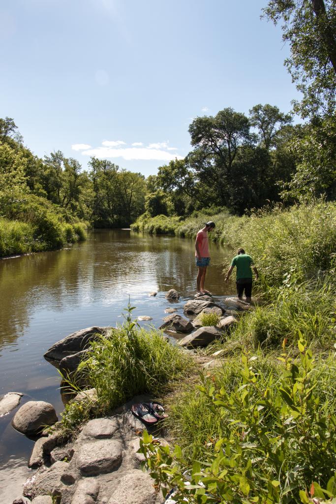
Constructed in the 1930s by the Civilian Conservation Corps (CCC), Turtle River State Park is located in a beautiful, wooded valley along the meandering Turtle River. The park features year-round recreational activities, including camping, picnicking, hiking, mountain biking, cross-country skiing and sledding.
Park guests enjoy shaded picnic areas and secluded camping sites. There are over 13 miles of trails carved through the forested hills and along the Turtle River. Anglers can also practice their fly fishing techniques in the trout-stocked river.
Perfect for weddings, family reunions and other group activities is the spacious Woodland Lodge, with its kitchen and dining hall. The upstairs of the Chalet/Warming House is also available to rent for just about any type of group function. The CCC Memorial Shelter offers a picturesque setting and is popular for wedding and large group picnics.
Standard Woodland Cabins
Includes: Basswood A, Basswood B, Elm A, & Elm B
Price: $80-95/night (two-night minimum stay required)
Basswood A & B each sleep six each with two queens and two twins, bunkbed style. Elm A & B are both accessible and sleep three each with one queen and one twin, bunkbed style. All cabins feature air conditioning, heat, electricity, full bathroom, charcoal grill, fire ring, and picnic table.
These cabins do not have kitchen amenities.
Premium Woodland Cabins
Includes: Ash, Cottonwood, Ironwood, & Oak
Price: $125-135/night (two-night minimum stay required)
These newly remodeled cabins are now full-service and include kitchen amenities along with air conditioning, heat, electricity, full bathroom, charcoal grill, fire ring, and picnic table.
Ash, Ironwood and Oak each sleep four with one queen bedroom and a second bedroom with a twin bunkbed.
Cottonwood is accessible and features two bedrooms, one with a queen bed and one with a twin bed. The living room area has a futon for extra sleeping space, so the cabin can sleep five total.
Overnight Rental Information
- Cabin users are expected to do general cleaning before vacating, including sweeping, wiping down surfaces and collecting and bagging trash.
- Check-in is after 4 pm, check-out is at noon.
- Smoking is not allowed in any cabins.
- Game or fish cleaning in or around cabins is not allowed, please contact park staff for other arrangements.
- Pets are not allowed in cabins.
- Bedding and towels are not provided.
- Find answers to other common questions about reservations here.
Campsite Types
67 Modern Campsites
(electricity & water)
Price: $25-30 per night
3 Modern Group Campsites
(the ability to put multiple units on one site)
Price: $25-30 per night, per unit
26 Primitive Campsites
Price: $15 per night
Book Now
Campground Maps
Full Park Map
Camping Information
- Campsites can be booked 95 days in advance from the date you wish to stay.
- Reservations can be made online or by calling 800-807-4723.
- Check-in is at 4:00 pm on the first day of the reservation and checkout is at 3:00 pm on the last day of the reservation.
- Pets are welcome but must stay on a leash. Most parks have off-leash areas or dog parks for your four-legged friends.
- Find answers to other common questions about reservations here.
Day-use Facilities
Woodland Lodge
The Woodland Lodge dining area seats up to 100. The facility has a fireplace and a full-service kitchen. Gas grill available for an additional $50/day fee. A two-day minimum rental required May 1-October 31 on weekends. It is available year-round and can be booked by calling the park at (701) 343-9099.
Woodland Lodge. . . . . . . . . . . . . . . . . $500/day
Chalet Meeting Room
Chalet meeting room seats 40 and is available year-round. The rental includes a fireplace, tables chairs and catering kitchen with microwave and refrigerator. No stove, dishes, or cookware provided. It is available year-round and can be booked by calling the park at (701) 343-9099.
Chalet Meeting Room. . . . . . . . . . . . . $250/day
Picnic Shelters
Two reservable shelters are available. The Agassiz shelter holds 40-50 people and the CCC Memorial Shelter holds groups up to 300. Picnic shelters can be booked by calling the park at (701) 343-9099.
Agassiz shelter . . . . . . . . . . . . . . . . . . . . . . . $25/day
CCC Memorial shelter . . . . . . . . . . . . . . . . $200/day
Additional Park Amenities
- Picnic shelters
- Playground
- Sewage dump station
- Showers and flush toilets
- Sledding area
- Visitor Center
- Warming house
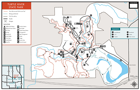
Turtle River State Park has a system of mountain biking, hiking, and interpretive trails. Winter users will find more than 7.5 miles of groomed cross-country ski trails, and plenty of opportunities for snowshoeing.
Fisher Loop
Distance: 0.65 miles
Open to: hiking, mountain biking, cross-country skiing, snowshoe
This wooded trail is accessed from the CCC Trail Head and returns to the same location. This trail crosses over the Turtle River and winds along the river corridor. It provides access to the River View and Timber trails and is groomed for cross-country skiing in winter.
Coneflower Loop
Distance: 0.6 miles
Open to: hiking, mountain biking, snowshoeing
This prairie and wooded trail is accessed from the via the Prairie Pass Trail. This trail loops through the prairie, into the wood line following the river corridor and returning to the prairie.
Timber Loop
Distance: 1.16 miles
Open to: hiking, mountain biking, cross-country skiing, snowshoe
This wooded trail is accessed from the CCC Trail Head via Fisher Loop and returns to the same location via River View. It begins along the Turtle River and meanders back through wooded hillsides. It is groomed along a modified route for cross-country skiing in winter.
Prairie Pass Trail
Distance: 0.64 miles
Open to: hiking, mountain biking, snowshoeing
This prairie trail is accessed from the CCC Trail Head via Fisher/ River View and ends at the Moose Head Trail accessed via the Woodland Lodge Trail Head. This trail meanders through the prairie, crossing the old entrance roadbed and features the old entrance booth as a resting location. Coneflower, Moose Head and River View trails can be accessed from this trail.
Moose Head Trail
Distance: 1.31 miles
Open to: hiking, mountain biking, snowshoeing
This scenic trail begins at the Woodland Lodge Trail Head and loops back to the Chalet and ball diamond. This trail is mostly wooded as it meanders along the creek corridor and features a foot-bridge crossing at the southeast end of the trail. Prairie Pass, River View, Eco Loop, and the Woodland Lodge can be accessed from this trail.
River View Trail
Distance: 1.05 miles
Open to: hiking, mountain biking, snowshoeing
This wooded trail is accessed from the CCC Trail Head via Fisher Loop and ends at the Woodland Lodge Trail Head. It begins by crossing the Turtle River and climbing the ridgeline that follows along the river with benches for viewing the river. The trail returns to the river corridor at the CCC Dam and ends at the Woodland Lodge. Prairie Pass, Moose Head and Timber trails can be accessed from this trail.
Eco Loop
Distance: 1.05 miles
Open to: hiking, cross-country skiing, snowshoe
This scenic trail begins at the Chalet Trail Head and ends on the Moosehead Trail. This trail features wooded hillsides, open prairies and views of the oxbow wetlands. Cattail trail access via this trail. A modified route is groomed for cross-country skiing in the winter.
Cattail Loop
Distance: 0.62 miles
Open to: hiking, snowshoeing
This trail is accessed via the Eco loop trail. It features a wildlife viewing station of the oxbow wetlands, boardwalk crossing of the oxbow, and finishes in the wooded hillside of the Eco loop trail.
Raven Ravine
Distance: 2.46 Miles
Open to: hiking, mountain biking, snowshoeing
This scenic trail begins at the CCC Trail Head and loops back to the Woodland Lodge. There are several connections to the campground, amphitheater, and the playground. This trail is mostly wooded as it meanders along the creek corridor, featuring a water crossing at the north end of the trail and two benches. Portions of this trail are groomed for Fat Tire Bikes and hiking in the winter.
Keystone Bridge
Distance: 0.84 Miles
Open to: hiking, mountain biking, snowshoeing
This scenic trail begins at the Trapper’s Rest Campground and ends at the Hollow’s Bridge parking area. There are several connections to the campground, Agassiz picnic area, and the Turtle River. This trail is wooded as it meanders along hillsides of the river corridor. Portions of this trail are groomed for Fat Tire Bikes and hiking in the winter.
Hollows
Distance: 1.74 Miles
Open to: hiking, mountain biking, snowshoeing, cross-country skiing
This scenic trail begins at the Visitor Center and ends at the Hillside Picnic Area with access to the Hollow’s Bridge parking and picnic area. This wooded trail winds through the hillsides and along the river corridor. Portions of this trail are groomed for Fat Tire Bikes and hiking, and others for cross-country skiing in the winter.
Trail Maps:
- A PDF Map of the summer trails is available here.
- A PDF Map of the winter trails is available here.
- All North Dakota State Park and Recreation Area trail maps are available in the OuterSpatial App.
- Paper park maps are also available at the park.
Click to view a printable schedule of our 2025 Summer Interpretive Programs.


.png)
